My feed
Premium

Please
or
to access all these features

Weather

Storm (Gareth?) Tuesday-Wednesday (12/13 March)

38 replies

GloriaSmud · 09/03/2019 14:01

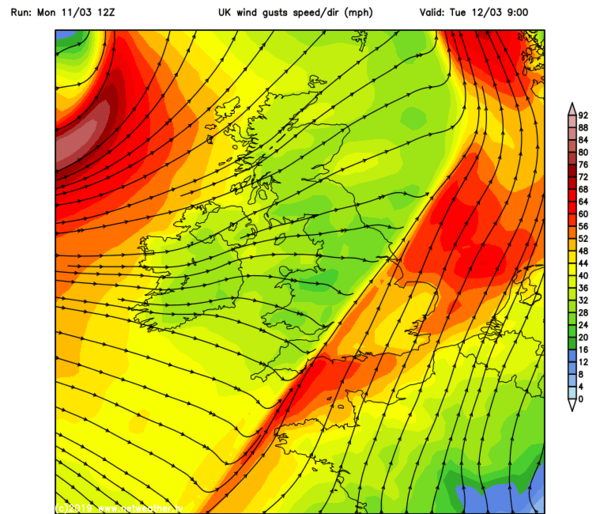
Wind warnings already issued by the metoffice for Tuesday and Wednesday.

(Storm hasn't been named yet but I think looking at the wind charts, it will become 'Storm Gareth' in the next few days.)

OP posts:
Report
Fazackerley · 15/03/2019 00:13

That wind map is cool

Report
oldsilver · 15/03/2019 00:09

Don't like it. Wind makes me anxious. Thought it was bad last night - luckily only lost my plastic greenhouse cover and a neighbour has lost most of the rendering of the chimney stack. Seems worse tonight.

Stay safe.

Report
Igneococcus · 13/03/2019 09:04

I have never seen so much water coming down as yesterday evening on my way home. There was rain, sleet and hail all at the same time.
Has calmed down now.

Report
Justmuddlingalong · 12/03/2019 17:47
Report
OhYouBadBadKitten · 12/03/2019 17:27

That must have been scary Magi, it was a potent front.

Of course Gareth isn't actually over, that was just a forerunner of the main event.

Report
magimedi · 12/03/2019 17:20

I was on the M20 - Dover to Ashford this afternoon & I don't ever remember driving through such heavy rain in this country. Stayed in the inside lane & slowed to about 35/40mph. Very scary but am home saf enow.

Report
GloriaSmud · 12/03/2019 12:18

The temperature here has dropped like a stone ~ 'tis now 4.3C and there's a hint of wintriness to what's falling from the sky.

OP posts:
Report
Justmuddlingalong · 12/03/2019 11:01

Just got very dark, windy and rainy here on the Fife coast.

Report
GloriaSmud · 12/03/2019 10:11
OP posts:
Report
GloriaSmud · 12/03/2019 10:10

Blackeyed ~ I didn't know whether you were applying that just to the weather or the country generally!

I think the squall line has just gone through here (Leicester) ~ it's chucked it down and the temperature's dropped from nearly 9C, 30 minutes or so ago to 6.7C now.

OP posts:
Report
BernardsarenotalwaysSaints · 12/03/2019 09:41

This mornings school run was not fun. The was blowing in my face there & back, pushing the double buggy was a right workout!

Report
Mummymorse · 12/03/2019 09:10

Hello

Report
BlackeyedGruesome · 12/03/2019 09:09

ps the oh fuck was to the squall line going through at school run timeish but equally applies to the risk of tornadoes, speaking as someone whose garage roof was moved 8 inches upward by doris.

thanks to oybbk I am now safely back home and about toi tuck up into bed again before doing the dreaded housework and admin.

Report
BlackeyedGruesome · 12/03/2019 08:10

shopping thursday then. lets hope the panic buying has not started then.

Report
OhYouBadBadKitten · 12/03/2019 08:00

Thursday's weather looks pretty benign.

Report
ajandjjmum · 12/03/2019 07:40

So.....flights out of LHR on Thursday evening unaffected??? Not being self-centred at all! Grin

Report
OhYouBadBadKitten · 12/03/2019 07:32

I have decided to postpone my cycle ride until tomorrow Grin

Report
OhYouBadBadKitten · 12/03/2019 07:31

ah, it's important to get the convective discussion in context. He's just saying potential is there and of course even if it were to occur, geographically speaking only tiny areas would be affected.

Report
Ethelswith · 12/03/2019 07:31

That all sounds 'fun' " I'm outdoors all morning (at least) and it sounds as if it could be lively.

Report
BlackeyedGruesome · 12/03/2019 07:26

oh fuck

Report
OhYouBadBadKitten · 12/03/2019 07:26

TORRO CONVECTIVE DISCUSSION 2019/003

A TORRO CONVECTIVE DISCUSSION has been issued at 01:20GMT on Tuesday 12th March 2019

Valid from/until: 01:20 - 14:00GMT Tuesday 12th March 2019 on for the following regions of the
United Kingdom & Ireland:

Eastern Ireland

Eastern N Ireland

S Scotland

England

Wales

THREATS

Wind gusts to 65mph; isolated tornadoes.

SYNOPSIS
A strong cold front will push eastwards across much of eastern Ireland and the UK tonight. A little CAPE is progged along the front, which is expected to be an ana-style cold front, with strong uplift in a shallow zone along the leading edge. Pronounced veering of the wind from southerly to westerly is expected along the front too. Finally, strong low-level wind shear is expected along the frontal zone. All of these ingredients suggest at least a small risk of a few brief tornadoes along the front, as well as very gusty winds. However, the lack of more obvious instability means that a watch is not deemed appropriate.

A small cluster of showers/possible thunderstorms could follow the front across S England and may also bring the risk of gusty winds/isolated tornadoes.

Forecaster: RPK

Report
OhYouBadBadKitten · 11/03/2019 20:40

Yes, I've grabbed a screen shot from the met office twitter.

Storm (Gareth?) Tuesday-Wednesday (12/13 March)
Report

Don’t want to miss threads like this?

Weekly

Sign up to our weekly round up and get all the best threads sent straight to your inbox!

Log in to update your newsletter preferences.

You've subscribed!

GloriaSmud · 11/03/2019 20:25

Is this the squall line showing up here for tomorrow morning? Could make for a not very pleasant rush-hour.

BBC report on Storm Gareth.

Storm (Gareth?) Tuesday-Wednesday (12/13 March)
OP posts:
Report
OhYouBadBadKitten · 11/03/2019 18:30

Models are showing a potential squall line developing tomorrow - this could lead to hail, thunder (and possibly some tornadic development???) if it does develop.

Report
OhYouBadBadKitten · 11/03/2019 18:23

That would explain it, yes, it does follow that way.

Report
Please create an account

To comment on this thread you need to create a Mumsnet account.