My feed
Premium

Please
or
to access all these features

Weather

Storm (Gareth?) Tuesday-Wednesday (12/13 March)

38 replies

GloriaSmud · 09/03/2019 14:01

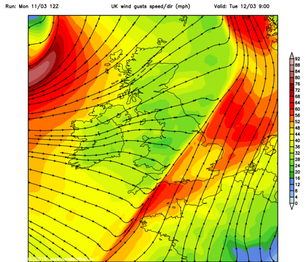
Wind warnings already issued by the metoffice for Tuesday and Wednesday.

(Storm hasn't been named yet but I think looking at the wind charts, it will become 'Storm Gareth' in the next few days.)

OP posts:
Report
TokyoSushi · 09/03/2019 21:09

Checking in!

Report
OhYouBadBadKitten · 09/03/2019 21:20

Some models show do show a deeper scenario than the met office forecast. We need amber warnings though before it gets named,

Report
BernardsarenotalwaysSaints · 09/03/2019 23:20

Next week looks messy & a bit of a case of "it's raining, must be school pick up time"

Report
GloriaSmud · 10/03/2019 07:24

BernardsarenotalwaysSaints Grin

We have a bit of light snow going on ~ some quite big flakes and a slight covering at the moment.

OP posts:
Report
OhYouBadBadKitten · 10/03/2019 08:19
Report
HarveySchlumpfenburger · 10/03/2019 10:01

Quite a few trees down this morning. Very very windy at 6am but has died down a bit.

Report
Grace212 · 10/03/2019 16:57

I live on a high floor so sometimes get confused about how bad it is outside when there's gale force winds

today it seems pretty awful in London/Essex even at ground level. Pity it's going to go on for a while.

Report
OhYouBadBadKitten · 11/03/2019 11:18

www.metoffice.gov.uk/weather/warnings-and-advice/uk-warnings#?date=2019-03-12

Updated warnings, covering a large area and bringing it forward. I'm the charts I'm seeing an extra little squeeze in isobars in the NE as it exits.

Still not 100% sure that it will be named though.

Report
GloriaSmud · 11/03/2019 11:26

Metoffice UK Storm Centre (where they officially announce that they've named storms, rather than people relying on what the Daily Mail/Express say!)

OP posts:
Report
Justmuddlingalong · 11/03/2019 14:16
Report
OhYouBadBadKitten · 11/03/2019 15:58

But why are they naming it? Have they changed their criteria? The criteria specifically state that a storm has a potential to require amber warnings. But when you look at the warnings matrix for this storm, it doesnt come under this category.

I think they are bowing to media pressure rather than following their own system.

Report
OhYouBadBadKitten · 11/03/2019 15:59
Report
GloriaSmud · 11/03/2019 16:42

I heard on the lunchtime forecast that Met Éireann had named it so is it a case of once one forecaster names a storm, the other side follows? (knowing that naming storms is 'a thing' between the two weather forecasters)

OP posts:
Report
OhYouBadBadKitten · 11/03/2019 18:23

That would explain it, yes, it does follow that way.

Report
OhYouBadBadKitten · 11/03/2019 18:30

Models are showing a potential squall line developing tomorrow - this could lead to hail, thunder (and possibly some tornadic development???) if it does develop.

Report
GloriaSmud · 11/03/2019 20:25

Is this the squall line showing up here for tomorrow morning? Could make for a not very pleasant rush-hour.

BBC report on Storm Gareth.

Storm (Gareth?) Tuesday-Wednesday (12/13 March)
OP posts:
Report
OhYouBadBadKitten · 11/03/2019 20:40

Yes, I've grabbed a screen shot from the met office twitter.

Storm (Gareth?) Tuesday-Wednesday (12/13 March)
Report
OhYouBadBadKitten · 12/03/2019 07:26

TORRO CONVECTIVE DISCUSSION 2019/003

A TORRO CONVECTIVE DISCUSSION has been issued at 01:20GMT on Tuesday 12th March 2019

Valid from/until: 01:20 - 14:00GMT Tuesday 12th March 2019 on for the following regions of the
United Kingdom & Ireland:

Eastern Ireland

Eastern N Ireland

S Scotland

England

Wales

THREATS

Wind gusts to 65mph; isolated tornadoes.

SYNOPSIS
A strong cold front will push eastwards across much of eastern Ireland and the UK tonight. A little CAPE is progged along the front, which is expected to be an ana-style cold front, with strong uplift in a shallow zone along the leading edge. Pronounced veering of the wind from southerly to westerly is expected along the front too. Finally, strong low-level wind shear is expected along the frontal zone. All of these ingredients suggest at least a small risk of a few brief tornadoes along the front, as well as very gusty winds. However, the lack of more obvious instability means that a watch is not deemed appropriate.

A small cluster of showers/possible thunderstorms could follow the front across S England and may also bring the risk of gusty winds/isolated tornadoes.

Forecaster: RPK

Report
BlackeyedGruesome · 12/03/2019 07:26

oh fuck

Report
Ethelswith · 12/03/2019 07:31

That all sounds 'fun' " I'm outdoors all morning (at least) and it sounds as if it could be lively.

Report
OhYouBadBadKitten · 12/03/2019 07:31

ah, it's important to get the convective discussion in context. He's just saying potential is there and of course even if it were to occur, geographically speaking only tiny areas would be affected.

Report
OhYouBadBadKitten · 12/03/2019 07:32

I have decided to postpone my cycle ride until tomorrow Grin

Report

Don’t want to miss threads like this?

Weekly

Sign up to our weekly round up and get all the best threads sent straight to your inbox!

Log in to update your newsletter preferences.

You've subscribed!

ajandjjmum · 12/03/2019 07:40

So.....flights out of LHR on Thursday evening unaffected??? Not being self-centred at all! Grin

Report
OhYouBadBadKitten · 12/03/2019 08:00

Thursday's weather looks pretty benign.

Report
BlackeyedGruesome · 12/03/2019 08:10

shopping thursday then. lets hope the panic buying has not started then.

Report
Please create an account

To comment on this thread you need to create a Mumsnet account.